National Register of Historic Places listings in Ashtabula County, Ohio

This is a list of the National Register of Historic Places listings in Ashtabula County, Ohio.
This is intended to be a complete list of the properties and districts on the National Register of Historic Places in Ashtabula County, Ohio, United States. The locations of National Register properties and districts for which the latitude and longitude coordinates are included below, may be seen in an online map.[1]
There are 41 properties and districts listed on the National Register in the county, including 1 National Historic Landmark. Another property was once listed but has been removed.
This National Park Service list is complete through NPS recent listings posted June 14, 2024.[2]
Map all coordinates using OpenStreetMap
Download coordinates as:
- KML
- GPX (all coordinates)
- GPX (primary coordinates)
- GPX (secondary coordinates)
Current listings
| [3] | Name on the Register[4] | Image | Date listed[5] | Location | City or town | Description |
|---|---|---|---|---|---|---|
| 1 | Ashtabula County Courthouse Group |  | June 30, 1975 (#75001316) | Northwestern corner of Jefferson and Chestnut Sts. 41°44′19″N 80°46′12″W / 41.7386°N 80.77°W / 41.7386; -80.77 (Ashtabula County Courthouse Group) | Jefferson | |
| 2 | Ashtabula Harbor Light | 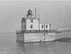 | August 4, 1983 (#83001943) | Ashtabula Harbor 41°55′06″N 80°47′45″W / 41.9183°N 80.7958°W / 41.9183; -80.7958 (Ashtabula Harbor Light) | Ashtabula | |
| 3 | Ashtabula Harbour Commercial District | 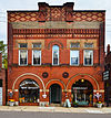 | September 5, 1975 (#75001311) | Both sides of W. 5th St. from its 1200 block to the Ashtabula River 41°53′58″N 80°47′59″W / 41.8994°N 80.7997°W / 41.8994; -80.7997 (Ashtabula Harbour Commercial District) | Ashtabula | |
| 4 | Ashtabula Main Avenue Historic District | Upload image | August 27, 2020 (#100005467) | Roughly bounded by Park Pl., Collins Blvd., West 48th St., Center St., and Park Ave. 41°51′56″N 80°46′56″W / 41.8656°N 80.7822°W / 41.8656; -80.7822 (Ashtabula Main Avenue Historic District) | Ashtabula | |
| 5 | Ashtabula Post Office and Federal Building | Upload image | June 17, 2019 (#100004053) | 4400 Main Ave. 41°52′02″N 80°46′53″W / 41.8672°N 80.7814°W / 41.8672; -80.7814 (Ashtabula Post Office and Federal Building) | Ashtabula | |
| 6 | Eliphalet Austin House |  | February 24, 1975 (#75001313) | 1879 State Route 45 in Austinburg 41°46′31″N 80°51′19″W / 41.7753°N 80.8553°W / 41.7753; -80.8553 (Eliphalet Austin House) | Austinburg Township | |
| 7 | Blakeslee Log Cabin |  | April 1, 1998 (#98000319) | 441 Seven Hills Rd., south of Ashtabula 41°50′41″N 80°46′09″W / 41.8447°N 80.7692°W / 41.8447; -80.7692 (Blakeslee Log Cabin) | Plymouth Township | |
| 8 | Boice Fort and Village Site |  | July 24, 1974 (#74001398) | Western side of Pymatuning Creek, near Wayne[6] 41°32′25″N 80°38′10″W / 41.5403°N 80.6361°W / 41.5403; -80.6361 (Boice Fort and Village Site) | Wayne Township | |
| 9 | Michael Cahill House |  | October 5, 1988 (#88001711) | 1106 Walnut Boulevard 41°54′04″N 80°48′01″W / 41.9011°N 80.8004°W / 41.9011; -80.8004 (Michael Cahill House) | Ashtabula | Bed and breakfast since 1986 |
| 10 | Castle Block | Upload image | March 26, 2020 (#100005127) | 323-355 Center St. 41°51′54″N 80°47′07″W / 41.8649°N 80.7852°W / 41.8649; -80.7852 (Castle Block) | Ashtabula | |
| 11 | The Cleveland Hotel |  | December 20, 2007 (#07001294) | 230-238 State St. 41°56′39″N 80°33′18″W / 41.9441°N 80.5551°W / 41.9441; -80.5551 (The Cleveland Hotel) | Conneaut | |
| 12 | Congregational Church of Austinburg |  | December 22, 1978 (#78002001) | State Route 307 in Austinburg 41°46′17″N 80°51′22″W / 41.7714°N 80.8561°W / 41.7714; -80.8561 (Congregational Church of Austinburg) | Austinburg Township | |
| 13 | Conneaut Harbor West Breakwater Light |  | April 10, 1992 (#92000243) | Western breakwater pierhead at the harbor entrance 41°58′47″N 80°33′29″W / 41.9797°N 80.5581°W / 41.9797; -80.5581 (Conneaut Harbor West Breakwater Light) | Conneaut | |
| 14 | Conneaut Light Station Keeper's Dwelling |  | August 21, 1992 (#92001078) | 1059 Harbor St. 41°58′01″N 80°33′07″W / 41.9669°N 80.5519°W / 41.9669; -80.5519 (Conneaut Light Station Keeper's Dwelling) | Conneaut | |
| 15 | Conneaut Works |  | July 30, 1974 (#74001393) | Off Mill Rd.[7] 41°56′13″N 80°34′11″W / 41.9370°N 80.5697°W / 41.9370; -80.5697 (Conneaut Works) | Conneaut | |
| 16 | David Cummins Octagon House |  | September 9, 1974 (#74001394) | 301 Liberty St. 41°56′28″N 80°33′26″W / 41.9411°N 80.5572°W / 41.9411; -80.5572 (David Cummins Octagon House) | Conneaut | |
| 17 | Eagle Cliff Hotel |  | October 20, 1995 (#95001197) | 5254 Lake Rd., E. 41°51′40″N 80°56′40″W / 41.8611°N 80.9444°W / 41.8611; -80.9444 (Eagle Cliff Hotel) | Geneva-on-the-Lake | |
| 18 | Joshua Reed Giddings Law Office | 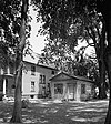 | May 30, 1974 (#74001396) | 112 N. Chestnut St. 41°44′26″N 80°46′09″W / 41.7406°N 80.7692°W / 41.7406; -80.7692 (Joshua Reed Giddings Law Office) | Jefferson | |
| 19 | Griggs Grange No. 1467 |  | December 13, 1995 (#95001414) | 1467 Brown Rd., north of Jefferson 41°47′19″N 80°42′47″W / 41.7886°N 80.7131°W / 41.7886; -80.7131 (Griggs Grange No. 1467) | Plymouth Township | |
| 20 | Francis E. Harmon House | 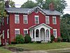 | February 24, 1975 (#75001312) | 1641 E. Prospect Rd. 41°52′28″N 80°46′32″W / 41.8744°N 80.7756°W / 41.8744; -80.7756 (Francis E. Harmon House) | Ashtabula | |
| 21 | Harpersfield Covered Bridge |  | November 3, 1975 (#75001315) | County Road 154 over the Grand River 41°45′22″N 80°56′40″W / 41.7561°N 80.9444°W / 41.7561; -80.9444 (Harpersfield Covered Bridge) | Harpersfield Township | |
| 22 | Harwood Block |  | March 21, 1978 (#78002002) | 246, 250, and 256 Main St. 41°56′39″N 80°33′21″W / 41.944167°N 80.555833°W / 41.944167; -80.555833 (Harwood Block) | Conneaut | |
| 23 | John Henderson House | 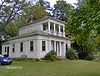 | November 7, 1976 (#76001368) | 5248 Stanhope-Kelloggsville Rd. in West Andover 41°36′28″N 80°36′44″W / 41.607778°N 80.612222°W / 41.607778; -80.612222 (John Henderson House) | Andover Township | |
| 24 | Hotel Ashtabula |  | June 20, 1985 (#85001342) | 4726 Main Ave. 41°51′50″N 80°46′58″W / 41.863889°N 80.782778°W / 41.863889; -80.782778 (Hotel Ashtabula) | Ashtabula | |
| 25 | Col. Erastus House House |  | July 30, 1974 (#74001397) | State Route 46 and Richmond-Footville Rd. at Rays Corner 41°41′00″N 80°46′51″W / 41.683472°N 80.780833°W / 41.683472; -80.780833 (Col. Erastus House House) | Lenox Township | |
| 26 | Col. William Hubbard House |  | March 20, 1973 (#73001385) | Corner of Lake Ave. and Walnut Boulevard 41°53′59″N 80°48′17″W / 41.899722°N 80.804722°W / 41.899722; -80.804722 (Col. William Hubbard House) | Ashtabula | |
| 27 | Jefferson Town Hall |  | June 18, 1981 (#81000428) | 27 E. Jefferson St. 41°44′19″N 80°46′05″W / 41.738611°N 80.768056°W / 41.738611; -80.768056 (Jefferson Town Hall) | Jefferson | |
| 28 | Kilpi Hall |  | December 12, 1976 (#76001365) | 1025 Buffalo St. 41°57′55″N 80°33′19″W / 41.965278°N 80.555278°W / 41.965278; -80.555278 (Kilpi Hall) | Conneaut | |
| 29 | Lake Shore & Michigan Southern Railroad Station |  | October 14, 1982 (#82001357) | 147 E. Jefferson St. 41°44′21″N 80°45′43″W / 41.739167°N 80.761944°W / 41.739167; -80.761944 (Lake Shore & Michigan Southern Railroad Station) | Jefferson | |
| 30 | Lake Shore And Michigan Southern Passenger Depot |  | March 27, 1975 (#75001314) | 342 Depot St. 41°56′59″N 80°33′33″W / 41.949722°N 80.559167°W / 41.949722; -80.559167 (Lake Shore And Michigan Southern Passenger Depot) | Conneaut | |
| 31 | Mother of Sorrows Church |  | March 9, 1995 (#95000170) | 1500 W. 6th St. 41°53′45″N 80°48′13″W / 41.895833°N 80.803611°W / 41.895833; -80.803611 (Mother of Sorrows Church) | Ashtabula | |
| 32 | New Lyme Institute |  | January 1, 1976 (#76001367) | 929 Brownville Rd. in South New Lyme 41°34′57″N 80°47′02″W / 41.582500°N 80.783889°W / 41.582500; -80.783889 (New Lyme Institute) | New Lyme Township | |
| 33 | New Lyme Town Hall | 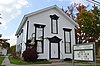 | August 6, 1975 (#75001317) | North of South New Lyme at 6000 State Route 46 41°35′09″N 80°46′42″W / 41.585972°N 80.778333°W / 41.585972; -80.778333 (New Lyme Town Hall) | New Lyme Township | |
| 34 | L. W. Peck House |  | January 1, 1976 (#76001366) | 2646 Eagleville Rd. in Eagleville 41°42′54″N 80°50′48″W / 41.715°N 80.846667°W / 41.715; -80.846667 (L. W. Peck House) | Austinburg Township | |
| 35 | Rock Creek School | 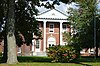 | February 9, 2005 (#05000023) | 2987 High St. 41°39′46″N 80°51′28″W / 41.662778°N 80.857778°W / 41.662778; -80.857778 (Rock Creek School) | Rock Creek | |
| 36 | Shandy Hall |  | June 28, 1974 (#74001395) | 6333 S. Ridge Rd., southwest of Geneva 41°46′55″N 80°58′57″W / 41.781944°N 80.982500°W / 41.781944; -80.982500 (Shandy Hall) | Harpersfield Township | |
| 37 | West Fifth Street Bridge |  | August 23, 1985 (#85001801) | State Route 531 over the Ashtabula River 41°54′01″N 80°47′53″W / 41.900278°N 80.798056°W / 41.900278; -80.798056 (West Fifth Street Bridge) | Ashtabula | |
| 38 | Windsor Corners District | 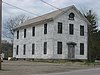 | September 5, 1975 (#75001318) | U.S. Route 322 and State Route 534 in Windsor 41°32′07″N 80°56′04″W / 41.535256°N 80.934422°W / 41.535256; -80.934422 (Windsor Corners District) | Windsor Township | |
| 39 | Windsor Mills Christ Church Episcopal | 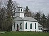 | May 29, 1975 (#75001319) | Wisell Rd. and U.S. Route 322 at Windsor Mills 41°32′09″N 80°57′43″W / 41.535833°N 80.961944°W / 41.535833; -80.961944 (Windsor Mills Christ Church Episcopal) | Windsor Township | |
| 40 | Windsor Mills Fort and Village Site | 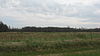 | October 21, 1975 (#75001321) | Off U.S. Route 322, southeast of Windsor Mills[8] 41°31′53″N 80°58′30″W / 41.531389°N 80.975000°W / 41.531389; -80.975000 (Windsor Mills Fort and Village Site) | Windsor Township | |
| 41 | Wiswell Road Covered Bridge | 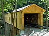 | April 11, 1973 (#73001386) | Wiswell Rd. over Phelps Creek at Windsor Mills 41°31′59″N 80°57′50″W / 41.533056°N 80.963889°W / 41.533056; -80.963889 (Wiswell Road Covered Bridge) | Windsor Township |
Former listing
| [3] | Name on the Register | Image | Date listed | Date removed | Location | City or town | Description |
|---|---|---|---|---|---|---|---|
| 1 | Park Avenue High School | Upload image | January 17, 1975 (#75002168) | September 15, 1975 | 4325 Park Avenue 41°52′07″N 80°46′59″W / 41.8687°N 80.783°W / 41.8687; -80.783 (Park Avenue High School) | Ashtabula |
See also
Wikimedia Commons has media related to National Register of Historic Places in Ashtabula County, Ohio.
- List of National Historic Landmarks in Ohio
- Listings in neighboring counties: Crawford (PA), Erie (PA), Geauga, Lake, Trumbull
- National Register of Historic Places listings in Ohio
References
- ^ The latitude and longitude information provided in this table was derived originally from the National Register Information System, which has been found to be fairly accurate for about 99% of listings. Some locations in this table may have been corrected to current GPS standards.
- ^ National Park Service, United States Department of the Interior, "National Register of Historic Places: Weekly List Actions", retrieved June 14, 2024.
- ^ a b Numbers represent an alphabetical ordering by significant words. Various colorings, defined here, differentiate National Historic Landmarks and historic districts from other NRHP buildings, structures, sites or objects.
- ^ "National Register Information System". National Register of Historic Places. National Park Service. April 24, 2008.
- ^ The eight-digit number below each date is the number assigned to each location in the National Register Information System database, which can be viewed by clicking the number.
- ^ Location derived from [=0044&display[]=220&display[]=237 this] page of Ohio History; the NRIS lists the site as "Address Restricted"
- ^ Squier, E.G., and E.H. Davis. Ancient Monuments of the Mississippi Valley. Washington: Smithsonian, 1848, plate 15.
- ^ Location derived from Mills, William C. Archeological Atlas of Ohio. Columbus: Ohio State Archeological and Historical Society, 1914, page 4 and plate 4. The NRIS lists the site as "Address Restricted".
- v
- t
- e
by county
- Adams
- Allen
- Ashland
- Ashtabula
- Athens
- Auglaize
- Belmont
- Brown
- Butler
- Carroll
- Champaign
- Clark
- Clermont
- Clinton
- Columbiana
- Coshocton
- Crawford
- Cuyahoga
- Darke
- Defiance
- Delaware
- Erie
- Fairfield
- Fayette
- Franklin
- Fulton
- Gallia
- Geauga
- Greene
- Guernsey
- Hamilton
- Hancock
- Hardin
- Harrison
- Henry
- Highland
- Hocking
- Holmes
- Huron
- Jackson
- Jefferson
- Knox
- Lake
- Lawrence
- Licking
- Logan
- Lorain
- Lucas
- Madison
- Mahoning
- Marion
- Medina
- Meigs
- Mercer
- Miami
- Monroe
- Montgomery
- Morgan
- Morrow
- Muskingum
- Noble
- Ottawa
- Paulding
- Perry
- Pickaway
- Pike
- Portage
- Preble
- Putnam
- Richland
- Ross
- Sandusky
- Scioto
- Seneca
- Shelby
- Stark
- Summit
- Trumbull
- Tuscarawas
- Union
- Van Wert
- Vinton
- Warren
- Washington
- Wayne
- Williams
- Wood
- Wyandot

Municipalities and communities of Ashtabula County, Ohio, United States | ||
|---|---|---|
County seat: Jefferson | ||
| Cities |  | |
| Villages | ||
| Townships | ||
| CDPs | ||
| Unincorporated communities | ||
| Footnotes | ‡This populated place also has portions in an adjacent county or counties | |
| ||


