Red Run Covered Bridge
Bridge in Pennsylvania, United States
40°10′34″N 76°05′00″W / 40.1762°N 76.0833°W / 40.1762; -76.0833
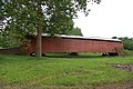
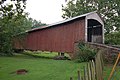
The Red Run Covered Bridge or Oberhaltzer's Covered Bridge is a covered bridge that once spanned the Muddy Creek in Lancaster County, Pennsylvania, United States. It was built in 1866 by Elias McMellen and is currently situated on private property next to the Red Run Campground. It is 107 feet long with a width of 15 feet and is also known as the Oberholzer's Covered Bridge.
The bridge has a single span, wooden, double Burr arch trusses design.[1] It is painted red, the traditional color of Lancaster County covered bridges, on the outside. Both approaches to the bridge are painted in the traditional white color.
The 107 foot long Red Run Covered Bridge is located at Red Run Campground and is on private property but it can easily be seen from the road. Built in 1866, this covered bridge is being used as a storage unit, this could be called a covered bridge to nowhere because the waters of Muddy Creek were diverted around the covered bridge in such a way that no water flows under its peers, another reason why this could be called a covered bridge to nowhere is because this covered bridge was replaced with a concrete span in 1961, a landlocked covered bridge is an ominous sight, and it can be imagined ghosts haunt here on Halloween.
The bridge's WGCB Number is 38-36-10. Added in 1980, it is listed on the National Register of Historic Places as structure number 80003539.[2] It is located at 40°10′34.2″N 76°5′0″W / 40.176167°N 76.08333°W / 40.176167; -76.08333 (40.17617, -76.08333).[3]
Dimensions
- Length: 107 feet (32.6 m) length or 128 feet (39 m) total length
- Width: 15 feet (4.6 m) total width
Gallery
-
 View of the front of the bridge
 -
 Side of the bridge
 -
 A three quarters view
 -
 A closer view
 -
 View from above towards river
 -
 View from above towards campground


See also
Wikimedia Commons has media related to Red Run Covered Bridge.
- Burr arch truss
- List of Lancaster County covered bridges
References
- "Red Run Covered Bridge". Lancaster County Pennsylvania Dutch Country Official Visitors Center. Pennsylvania Dutch Convention & Visitors Bureau. 2006. Retrieved 2006-07-07.
- "The Covered Bridges of Lancaster County". Lancaster County, PA Government Portal. County of Lancaster, Pennsylvania. 2001-11-09. Archived from the original on 2005-12-26. Retrieved 2006-07-07.
- ^ McCain, Dr. Roger A. "Red Run Mill Bridge". A Guide to Old Covered Bridges of Southeastern Pennsylvania and nearby areas. Retrieved 2006-08-04.
- ^ "PENNSYLVANIA - Lancaster County". National Register of Historic Places. Retrieved 2007-03-20.
- ^ Travis, Dale. "38-36-10". Round Barns & Covered Bridges. Retrieved 2006-08-08.
- v
- t
- e
- Contributing property
- Keeper of the Register
- Historic district
- History of the National Register of Historic Places
- National Park Service
- Property types

- Adams
- Allegheny
- Armstrong
- Beaver
- Bedford
- Berks
- Blair
- Bradford
- Bucks
- Butler
- Cambria
- Cameron
- Carbon
- Centre
- Chester
- Clarion
- Clearfield
- Clinton
- Columbia
- Crawford
- Cumberland
- Dauphin
- Delaware
- Elk
- Erie
- Fayette
- Forest
- Franklin
- Fulton
- Greene
- Huntingdon
- Indiana
- Jefferson
- Juniata
- Lackawanna
- Lancaster
- Lawrence
- Lebanon
- Lehigh
- Luzerne
- Lycoming
- McKean
- Mercer
- Mifflin
- Monroe
- Montgomery
- Montour
- Northampton
- Northumberland
- Perry
- Philadelphia
- Pike
- Potter
- Schuylkill
- Snyder
- Somerset
- Sullivan
- Susquehanna
- Tioga
- Union
- Venango
- Warren
- Washington
- Wayne
- Westmoreland
- Wyoming
- York
 Category
 NRHP portal


