Lower Oder Valley National Park
National Park on the German-Polish border
53°03′0″N 14°16′0″E / 53.05000°N 14.26667°E / 53.05000; 14.26667105 km2 (41 sq mi) Germany
60 km2 (23 sq mi) Poland
Park 2
16303 Schwedt
The Lower Oder Valley International Park is a shared German-Polish nature reserve. It comprises the western banks of the Oder (Polish: Odra) river within the Uckermark district in the German state of Brandenburg as well as the steep eastern banks in the Gryfino and Police counties of the Polish West Pomeranian Voivodeship further north.
The German part of the core area is the Nationalpark Unteres Odertal (Lower Oder Valley National Park). There is an information centre at Criewen. The Polish part of the core area is the Park Krajobrazowy Dolina Dolnej Odry (Lower Odra Valley Landscape Park).
The area comprises 165 km2 (64 sq mi) (Germany 105 km2 (41 sq mi), Poland 60 km2 (23 sq mi)); together with adjoining nature reserves in Germany and Poland the total area is 1,172 km2 (453 sq mi). By decision of the German-Polish Environmental Council in 1992 the German, Polish and Brandenburg environment ministers as well as the voivode of Szczecin created the Lower Oder Valley International Park.
The flat western shore of the Oder features several levees, which in order to control the water level and to prevent highfloods are regularly opened in winter and spring. The water flows freely into extensive floodplains covered until April when the dikes are closed again and the remaining water is drained.
Fauna
There is a Special Protection Area (SPA) for birds.[1] These plains are habitats for birds such as the black stork, the aquatic warbler, and the corn crake. There are animals such as the European otter and the European beaver.
Flora
There are plants like the submediterranean pubescent oak.
Gallery
-
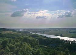 View from Krajnik Dolny on the Polish side of the border
 -
 Winter on the River Oder near Krajnik Dolny
 -
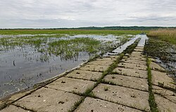 Concrete slab path in Lower Oder Valley National Park near Schwedt


References
- ^ BirdLife International (2012) Important Bird Areas factsheet: Lower Oder valley. Downloaded from http://www.birdlife.org on 27/11/2012
External links
Wikimedia Commons has media related to Nationalpark Unteres Odertal.
- National park site
- Tourism Association (in German)
- v
- t
- e

Authority control databases | |
|---|---|
| International |
|
| National |
|
 | This Brandenburg location article is a stub. You can help Wikipedia by expanding it. |
- v
- t
- e
 | This article related to a protected area in Europe is a stub. You can help Wikipedia by expanding it. |
- v
- t
- e


