List of Pennsylvania state historical markers in Butler County

This is a list of the Pennsylvania state historical markers in Butler County.
This is intended to be a complete list of the official state historical markers placed in Butler County, Pennsylvania by the Pennsylvania Historical and Museum Commission (PHMC). The locations of the historical markers, as well as the latitude and longitude coordinates as provided by the PHMC's database, are included below when available. There are 15 historical markers located in Butler County.[1]
Map all coordinates using OpenStreetMap
Download coordinates as:
- KML
- GPX (all coordinates)
- GPX (primary coordinates)
- GPX (secondary coordinates)
Historical markers
| Marker title | Image | Date dedicated | Location | Marker type | Topics |
|---|---|---|---|---|---|
| Butler County | 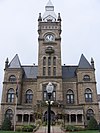 | June 11, 1982 | County Courthouse, Main Street (PA 8), Butler 40°51′31″N 79°53′44″W / 40.85857°N 79.89545°W / 40.85857; -79.89545 (Butler County) | City | George Washington, Government & Politics, Government & Politics 19th Century, Religion |
| General Richard Butler - PLAQUE | May 1, 1917 | County Courthouse, Butler 40°51′31″N 79°53′44″W / 40.85857°N 79.89545°W / 40.85857; -79.89545 (General Richard Butler - PLAQUE) | Plaque | American Revolution, Ethnic & Immigration, Military | |
| George Edward Waddell |  | July 26, 2003 | Main Street (PA 488) at Moraine Elementary School, Prospect 40°54′17″N 80°02′33″W / 40.904624°N 80.042599°W / 40.904624; -80.042599 (George Edward Waddell) | Roadside | Baseball, Sports |
| George Washington | 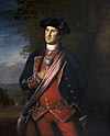 | February 15, 1970 | PA 68, 1.8 miles northeast of Evans City (MISSING) | Roadside | Forts, French & Indian War, George Washington, Military, Native American |
| Harmonist Cemetery |  | October 3, 1947 | Evans City Road (PA 68) & Edmonds Road, Harmony 40°48′06″N 80°07′25″W / 40.80177°N 80.1237°W / 40.80177; -80.1237 (Harmonist Cemetery) | Roadside | Religion |
| Harmony |  | October 3, 1947 | Main Street at Mercer Street in Harmony 40°48′10″N 80°07′40″W / 40.80267°N 80.12785°W / 40.80267; -80.12785 (Harmony) | Roadside | Religion |
| Harmony Mennonites |  | October 3, 1947 | Perry Highway (US 19) & Mennonite Lane, north of Zelienople 40°48′33″N 80°07′46″W / 40.80927°N 80.12942°W / 40.80927; -80.12942 (Harmony Mennonites) | Roadside | Religion |
| Invention of the Jeep |  | October 17, 1993 | Hansen Avenue and Renaissance Avenue, Butler 40°51′26″N 79°54′42″W / 40.85713°N 79.9116°W / 40.85713; -79.9116 (Invention of the Jeep) | Roadside | Business & Industry, Military, Military Post-Civil War, Transportation |
| Old Stone House | 1968 | At site, PA 8 & PA 173, Stone House 41°00′45″N 80°00′08″W / 41.012617°N 80.002126°W / 41.012617; -80.002126 (Old Stone House) | Roadside | Buildings, Business & Industry, Houses & Homesteads | |
| Old Stone House | 1968 | At site, PA 8 & PA 173, Stone House (MISSING) | Roadside | Buildings, Business & Industry, Houses & Homesteads | |
| Rev. Richard C. Christy | 2004 | At church, 455 Clearfield Road, Fenelton 40°50′34″N 79°44′35″W / 40.842750°N 79.742983°W / 40.842750; -79.742983 (Rev. Richard C. Christy) | Roadside | Civil War, Religion | |
| Roeblings, The | 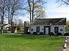 | October 6, 1947 | Butler Street near High Street, Saxonburg 40°45′19″N 79°49′05″W / 40.755155°N 79.818095°W / 40.755155; -79.818095 (Roeblings, The) | Roadside | Bridges, Business & Industry, Invention, Professions & Vocations, Transportation |
| Venango Path |  | February 18, 1995 | Franklin Road at Mars Crider Road (PA 228), Cranberry Township 40°41′08″N 80°04′30″W / 40.6856°N 80.07512°W / 40.6856; -80.07512 (Venango Path) | Roadside | Forts, George Washington, Military, Native American, Paths & Trails, Roads, Transportation |
| William A. Smith | January 1, 1955 | North Pike Road (PA 356) & Cooper Road, Cabot 40°46′06″N 79°47′14″W / 40.7684°N 79.78732°W / 40.7684; -79.78732 (William A. Smith) | Roadside | Business & Industry, Oil & Gas, Professions & Vocations | |
| Zelienople |  | October 3, 1947 | North Main Street/ Perry Highway (US 19) at Connoquenessing Creek, Zelienople 40°48′00″N 80°08′17″W / 40.8°N 80.13795°W / 40.8; -80.13795 (Zelienople) | Roadside | Buildings, Cities & Towns |
See also
 Pennsylvania portal

- List of Pennsylvania state historical markers
- National Register of Historic Places listings in Butler County, Pennsylvania
References
- ^ "PHMC Historical Markers Search" (Searchable database). Pennsylvania Historical and Museum Commission. Commonwealth of Pennsylvania. Retrieved 2010-07-19.
External links
- Pennsylvania Historical Marker Program
- Pennsylvania Historical & Museum Commission
- v
- t
- e
Municipalities and communities of Butler County, Pennsylvania, United States
County seat: Butler
- Butler

- Bruin
- Callery
- Cherry Valley
- Chicora
- Connoquenessing
- East Butler
- Eau Claire
- Evans City
- Fairview
- Harmony
- Harrisville
- Karns City
- Mars
- Petrolia
- Portersville
- Prospect
- Saxonburg
- Seven Fields
- Slippery Rock
- Valencia
- West Liberty
- West Sunbury
- Zelienople
communities
‡This populated place also has portions in an adjacent county or counties
- Pennsylvania portal
- United States portal
| ||||||||||
|---|---|---|---|---|---|---|---|---|---|---|
| Counties |
|  | ||||||||
| Major cities | ||||||||||
| Cities and towns 15k–50k (in 2010) | ||||||||||
| Airports | ||||||||||
| Topics | ||||||||||
| ||||||||||


